
Driving to Burning Man from Seattle/Portland

Major mapping error: BM 2019
Driving to Burning Man from Seattle or Portland s a long one-day undertaking or an easy two-day endeavor. We cover detailed driving directions, including where to stop for food and gas, where to camp if you are going overnight, and when to arrive at the event.
It’s important to note that you will lose cell coverage during this trip, and that all mapping programs repeatedly have errors and sometimes absurd routes (see image insert). Printing this page may avoid some major headaches.
Wait Times | When to Arrive
At times, the wait to enter or exit Burning Man is significant. In 2018, we waited 11 hours in line following an extended dust storm.
One way to avoid a long wait is to obtain an Early Access Pass (“EAP”), also known as a Work Access Pass. Typically, these are given to camps, artists, and mutant vehicle operators who need to arrive before the start time to get things set up. Each pass specifies the date after which the pass is valid, and historically, the earliest a pass is valid for is the Monday the week before the event opens.
Source: Juliet Hougland
Absent a EAP, the earliest you can get into Black Rock City is 12:01 am Sunday Morning. As you arrive at BRC, you will drive off of the paved NV Highway 35 onto a well maintained dirt road, called The Gate Road. Approximately 3.3 miles later you will encounter a ticket taker, who will scan your tickets and vehicle pass. Your vehicle will be searched for stowaways. Once clear, you’ll drive the last 1.4 miles (at 5 mph) and enter the city.
But when should you arrive at gate road? Here there is some gamesmanship to be had if you care about waits.
If you arrive between 12:01 am Sunday, and 6 am Sunday, your wait will be short… less than two hours. But if you arrive a bit early, or show up late Sunday evening, you may have a much longer wait.
A Note About Arriving Before the Gate Opens
Don’t Be Early. Seriously.
Unless you have an early access pass, your best bet is to arrive at the gate just before midnight on Sunday morning. Our strategy is to drive to Rabbit Trax in Cedarville for the final fuel up, and then kill a bit of time, getting food or relaxing. Around 9:45 pm start the final leg to BRC, driving through Eagleville, and keep driving until around 11 pm. Then start to watch for a turn out to rest in…there are several along the last 20 miles to BRC. Relax until our navigation has you arriving at BRC at 11:45 pm and start the final leg.
Ok, so why the fuss about being precise about arrival times? The org has this to say about arriving early:
If you arrive in the hours before 12:01 am Sunday, August 25, please DO NOT wait on the side of the road along Hwy 447, CR 34 or in Gerlach or Empire. Your best option is to proceed down Gate Road and park in the Staging Lot. This will give you an opportunity to rest, stretch your legs, retrieve Will Call tickets from the Box Office, ponder the vagaries of life and meet your neighbors. You will not be penalized for arriving early. (You also don’t get in any earlier).
Sadly, this is utter b.s. You are very much penalized for arriving at the ticket taker window before midnight. We know this because we sent one of our crew to watch and document exactly how the gate opening worked. Here’s how it went in 2019:
If you arrived before 11:50 pm, Saturday night you were directed to the “Staging Lot” (nomenclature note: If you arrive early, you go to the Staging Lot… If you arrive and have a ticketing issue, a bad car pass, etc., you are directed to the “D lot” until the issue is resolved). By midnight there were around 500 vehicles in the Staging Lot. At 11:50 pm they stopped directing cars to the Staging Lot, and just held traffic at the main ticket area.
At midnight…nothing whatsoever happened. At 12:15 pm, the main gate began allowing vehicles in from the main line and the Staging Lot. The first person into BRC without early access this year arrived at the ticket taker at exactly 11:50 pm in a Rider truck, and was admitted to the event at 12:15 pm. There were around 9 lanes of ticket takers. They assigned one of the nine lanes as dedicated to the Staging Lot, and 8 to the normal lines.
Our estimates were as follows for arrival time vs. admission time:
Arrival Admission
Before 6 pm 12:15 am to 1 am
6 pm to 8 pm 1 a.m. to 2:30 am
8 pm to 10 pm 2:30 am to 4 am
10 pm to 11:50 pm 4 am to 5 am
11:50 pm to midnight No wait
Midnight to 1 am Less than 30 minutes wait.
So get this. If you arrived at 11:49 pm, your wait was around 5 hours. If you arrived one minute later, your wait was 25 minutes.
When to leave is less complicated than arrival times. If you want to scram early, just leave Sunday around noon. Wait times ramp up more quickly after the Temple Burn, peaking around 7 a.m. Monday morning, when they begin to drop again.
Source: Juliet Hougland
Various Resources
Actual sunrise/sunset at BRC (adjusted for terraine)
Listen to 94.5 FM for BM traffic information, 95.1 FM for Gate Info. You won’t get reception until you are near the event.
Information re the drive from PNW to BRC
Sunrise/Sunset: 6:25 a.m/7:52 p.m on drive
Last Fuel Stops Before BRC (Coming from the Pacific Northwest)
You’ll want to arrive at Black Rock City with as much fuel as possible if you’re in an RV or using your car’s tank to store gas for generators. The last fill up point is Cedarville, around 98 miles from BRC. Rabbit Traxx, Cedarville’s sole gas station as of 2023, is well-equipped to handle the rush. Immediately before Cedarville, you pass through Alturas, where you can get gas, but at a higher price.
We typically fill our tank in Klamath Falls, and then top off at Rabbit Trax in Cedarville. (Alteras is often 10 percent more expensive than Klamath Falls, but as of July 2023 prices were closer than historically has been the case). In 2023, AMA Mini Mart in K-Falls was $4.36/gal regular unleaded. The lowest price in Alteras (Chimney Rock) was $4.49. Rabbit Traxx in Cedarville was $4.39/gal.
The AMA Mini Mart typically has the lowest prices in Klamath Falls. But check here for latest prices.
Here are the last fuel stops before arriving at Burning Man:
Alturas (117 miles from BRC)
-Chimney Rock Travel Center typically has the least expensive gas. It’s on the right, immediately before you turn off on 299 to Cedarville.
-Modoc Mini Mart is also a low price option, but is quite run down and dirty, so we prefer Chimney Rock, which is clean and well-maintained.
-Other stations prices are available here.
Cedarville (98 miles from BRC)
Rabbit Traxx. Open 24 Hours-a-day during Burning Man. Confirm hours here. Check pricing here.
Consider tipping attendants in the gas station if they pump your gas.
How to Get There
Route Overview:
Seattle to Portland
to Eugene
to Klamath Falls
to Alturas, CA
to Cedarville
to just North of Gerlach
to BRC
Map of Drive from Portland to BRC
Detailed Driving Directions
Seattle to Portland, Oregon
Distance: 168 mi.
Driving time: 3 hours
While you can avoid Portland, almost everyone will do the direct route down I-5 to Portland.
Your first major town will be Olympia.
Pass through Grand Mound (18.7 mi from Olympia).
Pass through Centralia (6.0 mi). Food options: Boccata Mediterranean (11 am to 3 pm), Big T BBQ (Closed Monday/Tuesday)
The Arco Station features some of the least expensive gas you’ll find between Seattle and Portland, with cash prices around $0.50 to $0.75 below average. Directions to Arco from Grand Mound. If you want some food on the gas stop, avoid the Arco (and their below par restrooms, and enjoy good local food)
Cross the Cowlitz River (23.8 mi)
Pass through Kelso (19.4 mi) Nipps Drive-Through (in Longview, a few minutes from Kelso. Directions here).
Pass through Kalma (10.8 mi) Food option: Antique Deli (lunch only)
Pass through Woodland (9.0 mi)
Cross the Lewis River and pass through Paradise Point Park. RV/tent camping and services available for around $32.
Pass through Ridgefield (7.4 mi)
Pass through Salmon Creek (is 8.3 mi)
Pass through Vancouver (6.5 mi)
Cross the Columbia River and enter Portland Oregon
Food Options:
Boccata Mediterranean, Centralia WA: Italian and Mediterranean food. Open 11 am to 3 pm. Closed Sundays.
Antique Deli, Kalama WA: Good quality sandwiches. Open 10 am to 5 pm Monday-Saturday and 11-5 on Sunday.
Nipps Drive-Through: Burgers, Garden Burger and Fried Chicken Sandwich. Basic good quality burgers. Open 10:30 am to 9 pm. Closed Sunday.
Gas Options:
Portland to Salem, Oregon
Distance: 45 mi.
Driving time: 40 Minutes
You will cross the Columbia River and drive through downtown Portland, before continuing on I-5 toward Salem
From Portland you will pass through Lake Oswego (9.5 mi)
Pass through Wilsonville (7.5 mi)
Cross the Willamette River (1 mi)
Pass through Woodburn (11 mi)
Enter Salem (19 mi)
Food Options:
Dar Essalam, Wilsonville, OR Moroccan Food. Open 11 am to 8 pm. Closed Sunday.
J's Teriyaki and Pub, Salem, OR Japanese. Open 11 am to 8 pm. Closed Sunday.
Hops n Drops, Keizer OR (near Salem), Sports bar. Open 11 am to 11 pm. Open 7 days a week.
Gas Options:
Costco Members: Costco in Wilsonville (directions), Tigard (directions), or in Salem (directions)(Gas prices). Salem typically has the cheapest Costco gas prices. Note, the Shell station below often has gas at the same price as Costco, with no waiting in line.
TA/Shell, 7 Minutes past Wilsonville (directions, gas prices)
Salem to Eugene, Oregon
Distance: 59 mi.
Driving time: 52 Minutes
The drive to Eugene continue on I-5, similar to the last leg.
Pass through Salem to Albany (20.3 mi)
Pass through Harrisburg (23.7 mi)
Enter Eugene (15 mi)
Food Options:
Oregon Barbecue, Albany. Drive-up BBQ shack. Picnic table outdoor seating only. Closed Sundays.
Elmer's Restaurant, Albany. Breakfast all day, plus normal diner options. Some wait during prime breakfast hours.
Coburg Pizza Company, Coburg (7 minutes before Eugene). Pizza and wings, open seven days a week.
Gas Options:
Costco Members: Costco in Albany.
Love’s in Albany. Typically the lowest price on the leg for non-Costco Members
Note: If you are low on gas, it’s cheaper to fill up before beginning the next leg.
Eugene to Klamath Falls, Oregon
Distance: 168 mi.
Driving time: 4 hours
From Eugene you will finally leave I-5, with more beautiful scenery than the last few hours. Lookout Point Lake is on your left and an hour later you will see Lake Odell as you pass through national forest land.
Just south of Eugene, take exit #188A to OR-58 (Willamette HWY) towards Oakridge/Klamath Falls. Keep going left at the fork in the ramp.
Take OR-58 to US-97 (86 mi total).
Pass through Goshen (6.6 mi).
Pass through Pleasant Hill (4 mi).
Pass through Trent (4 mi).
Pass through Minnow (7.2 mi).
Pass through Crale (5.7 mi).
Pass through Hampton (4 mi).
Pass through Willamette City (9.5 mi).
Pass through Oakridge (1.4 mi). Kitson Hot Springs is 4.6 mi away down Kitson Springs Rd.
Pass through McCredie Springs (10 mi – 18 min).
You will cross the Willamette Pass (5,128 ft).
You will pass Crescent Lake.
Pass through Crescent Lake Junction (24 mi – 42 min).
When you will reach US-97, turn slightly right and head south toward Klamath Falls (16.7 mi).
Take US-97 to Klamath Falls (78 mi total).
Pass through Chemult (11 mi).
Pass thorough Beaver Marsh (18 mi).
Pass by Modoc Point (50 mi).
At Modoc, you will follow the shoes of Upper Klamath Lake into Klamath Falls (20 mi).
Pass through Algoma (21 mi).
Food Options:
Stewart's 58 Drive-in, Oakridge. Burger and Shake joint. 7 am to 3 pm. Closed Monday and Tuesdays.
Lee's Gourmet Garden, Oakridge. Open Noon to 8:30 pm. Closed Mondays.
Gas Options:
Oakridge Gas Stations. Mobile tends to be cheapest, but you can eyeball prices of the three stations as you arrive.
Sinclair, Crescent Lake. Usually 5 to 10% above the lowest price in Oakridge.
Chevron, right after OR-58/OR-98 junction.
Klamath Falls to Alturas, CA
Distance: 100 mi.
Driving time: 2.5 hours
You will hit stop signs and some local traffic as you navigate Klamath Falls. You will shortly be leaving Oregon, and you will encounter a California Agriculture Inspection Station during this leg (see note below).
Stay straight on US-97 (2 mi) with Klamath Falls on your left.
Use the right lane to take the State Route 66/State Route 140 ramp to Lakeview/Medford
At the stop sign turn left onto OR-140 E/OR-66 E (6 mi)
Drive in right lane and turn right onto OR-39 (5 mi).
Pass through Merrill (12.3 mi)
OR-39 becomes CA-139 at the California border. Head south to CA-299 (56 mi total).
Pass through Tule Lake (8 mi – 15 min).
Pass through Newell (7 mi – 14 min).
Pass by Copic (2 mi).
Stop at the California Agricultural Station. You will be asked what fruits and vegetables you might be carrying (12 mi).
You will pass by Perez (2.6 mi).
You will pass through Ambrose (20 mi).
Continue to the intersection of CA-139 and CA-299 (8 mi).
Take a left at CA-299 and head East to Alturas, CA (19 mi).
Just past the interchange, you will pass through Canby (1 mi).
Enter Alturas, CA.
A note on the California Inspection Station. First, relax. These people are almost always friendly, and doing a simple job of preventing certain fruits and vegetables from entering California. Read up on what is restricted here. From Oregon the following are not permitted: all citrus fruit, Butternut, Cherries, Chestnuts, hickory nuts, pecans in the shell, and walnuts in the shell. Avocados are likely to be inspected for mold and insects. Other less common nuts in shells may be restricted from time to time. It’s best to have any food you are declaring handy for inspection.
Food Options:
Klamath Falls has many food options, and is a good place to stretch your legs. See your options here.
There are several decent food options in Alturas:
Harold's Frosty is a decent burger and fries place.
Gas Options:
Gas strategy comes into play here. We typically fill our tank in Klamath Falls, and then top off at Rabbit Trax in Cedarville. Alteras is a good 10 percent more expensive than Klamath Falls. In 2019, AMA Mini Mart was $2.95/gal regular unleaded. The lowest price in Alteras (Chimney Rock) was $3.50. Rabbit Traxx in Cedarville was $3.35/gal. We filled our 70 gallon tank at AMA, and then topped off with 10 gallons at Rabbit Traxx, saving around $35 by not just filling up at Rabbit Traxx.
The AMA Mini Mart typically has the lowest prices in Klamath Falls. But check here for latest prices.
There are gas stations in Alturas, but the prices are around 10 percent higher. Chimney Rock Travel Center is the lowest price, and also has the benefit of being clean.
Alturas, CA to Cedarville, CA
Distance: 23 mi.
Driving time: 32 minutes
After leaving Alturas you will head up a steep climb to the Cedarville Pass (6,305 ft at top). You’ll coast all the way from the pass to downtown Cedarville. Use your low gear to avoid burning up your brakes. You’ll want to top off your gas in Cedarville. As of 2019 Rabbit Traxx is the only operational gas station, but there are rumors of a second gas station re-opening by the 2020 Burn.
Note, there are often police in Alturas, and is one of the most policed legs of the journey from the Pacific Northwest.
Drive through Alturas. CA-299 becomes US-395 at Main Street where the road veers to the left (8 mi)
8 miles past Main street, veer right onto CA-299 and begin the climb to the pass, and then the steep descent to Cedarville (13.9 miles)
Stop at Rabbit Traxx, top off your fuel. Consider getting a milk shake inside.
Cedarville, CA to Gerlach, NV
Distance: 84 mi.
Driving time: 1.75 hours
After leaving Rabbit Traxx, you’ll drive down to Main Street. Here you can stop to get food, or head out on the desolate and at times windy road that will bring you to Black Rock City. The time it takes to complete this leg will depend highly on the time of day, and the type of vehicle you are driving. Driving a 35’ RV, you may take over two hours. In a decent car, and some passing skills, you may make it in closer to 90 minutes.
Take a right out of Rabbit Traxx (or continue straight if you aren’t stopping) until you reach the stop sign on the main drag.
Turn right onto Main Street. Drive slowly through town, and continue straight. Main Street changes names to Surprise Valley Road after a few minutes.
Pass through tiny Eagleville (15.5 mi). Please drive slowly through town.
To the left, you will see Lower Alkali Lake, and other small water features if you look carefully.
You will continue on for an hour, and if in an RV, you’ll want to exercise care with the tricky curves.
You pass Planet X Pottery (61 mi). Watch for frequent police in this area.
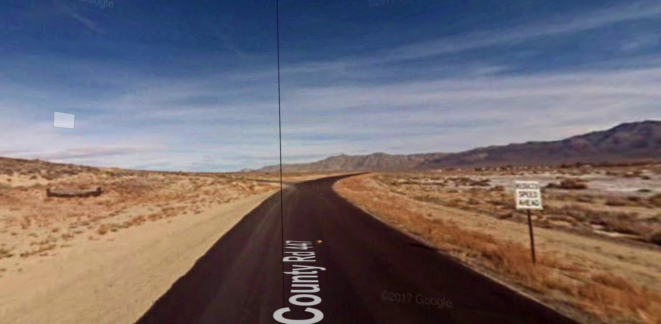
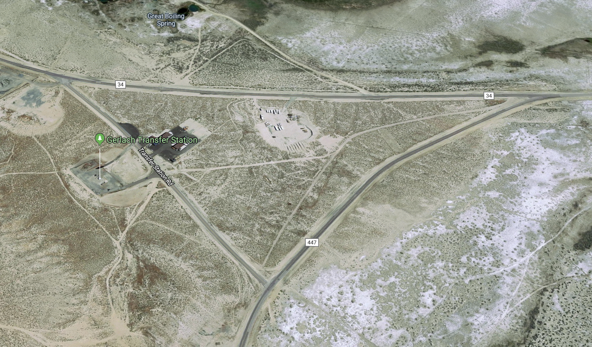
Continue on for 7.1 miles. Watch for a poorly marked left turn (see images below). If you happen to see the left turn right after the “Reduce Speed Ahead” sign, turn there. If you miss it, don’t worry, you’ll hit country Road 34, and take almost a U turn.
Note: By taking the unmarked first left turn, you’ll avoid around 1/2 mile of potentially slow moving traffic from San Francisco and points south.
Final Leg to Burning Man
Distance: 8.5 mi.
Driving time: variable
Take a left on to NV-34 (8.5 mi).
Turn right onto the marked dirt road. The speed limit is 10 mph until you reach the ticket booth, which is 3.3 miles on the dirt road.
After submitting your ticket and having your vehicle inspected for stowaways, you will proceed at 5 mph to BRC, 1.3 miles down the road.
Important note: There is a heavy police presence on the dirt road. Under no circumstances speed. Have your seat belt on. Do not have any open container in the car. If you arrive during a peak period you will likely see someone having their vehicle carefully searched, probably because they had some type of contraband in plain sight while driving in, usually a beer or a joint. Don’t be that person.
And etiquette dictates you do not change lanes once you’ve hit slowing traffic. Soon enough, you will be home.